18. Thank You & Next Steps

Thank you for your participation

Next Steps

  • Following PIC #1 we will:
    • Respond to comments received during PIC #1 Comment Period (April 22, 2021 to May 6, 2021)
    • Assess and evaluate various Preliminary Design Refinements and Alternatives and select the Preferred Preliminary Design Refinements/Alternatives
    • Present the Preferred Preliminary Design at PIC #2 which is anticipated to be held Fall 2022
    • Complete the Preliminary Design and Environmental Assessment which is anticipated Early 2023
    • Prepare a Transportation Environmental Study Report (TESR) – End of 2022
    • Notify and provide timing for the 30-day public and agency review period for TESR
      Prepare the Preliminary Design Study and applicable Environmental Frameworks for future design stages

Contact us if you have any questions or comments.
17. Leslie Street Interchange

Leslie Street Interchange Base Case from 2002 Approved Environmental Assessment

Base Case from 2002 Approved EA Alignment

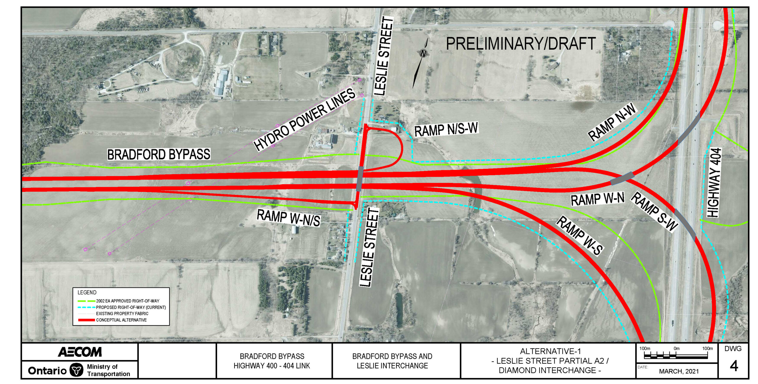
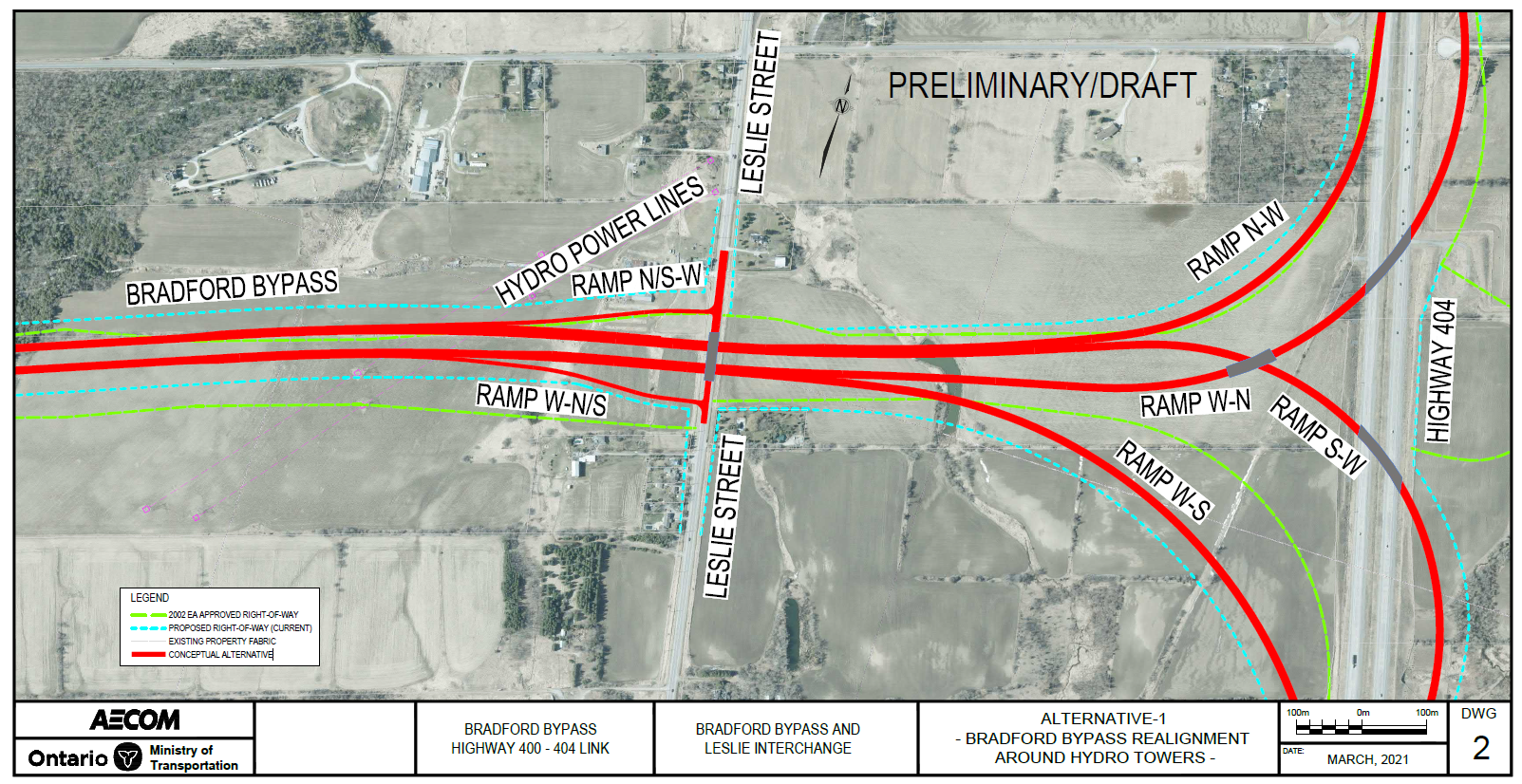
Refinement Alternative 1 – Parclo A2

  • Consists of two on-ramps and one off-ramp to and from the west.
  • Traffic signals at the end of two off-ramps (if warranted).
  • Bradford Bypass over the Leslie Street bridge.
  • Property footprint is beyond the 2002 Approved EA Right-of-Way. Property impacts in the northeast quadrants. Footprint may be further impacted by the alignment refinement alternatives to avoid hydro towers west of Leslie Street.
(click to enlarge)

Key Considerations

Environmental

  • Built Heritage (one listed Cultural Heritage Landscape).
  • Fish and Fish Habitat.
  • Groundwater (domestic water wells).
  • Land Use (Greenbelt, Whitebelt, Protected Countryside).
  • Surface Water (drainage, multiple warm water watercourse).
  • Terrestrial Ecosystems (Species at Risk, unevaluated wetlands).

Transportation & Engineering

Engineering

  • Interchange configurations.
  • Traffic operations based on demand, weaving, and level of service.
  • Complexities in traffic staging, constructability and utility relocation.
  • Structural / grading considerations.

Property Impacts

  • Interchange footprint linked to mainline hydro utility refinement alternatives.

16. Bathurst Street Interchange

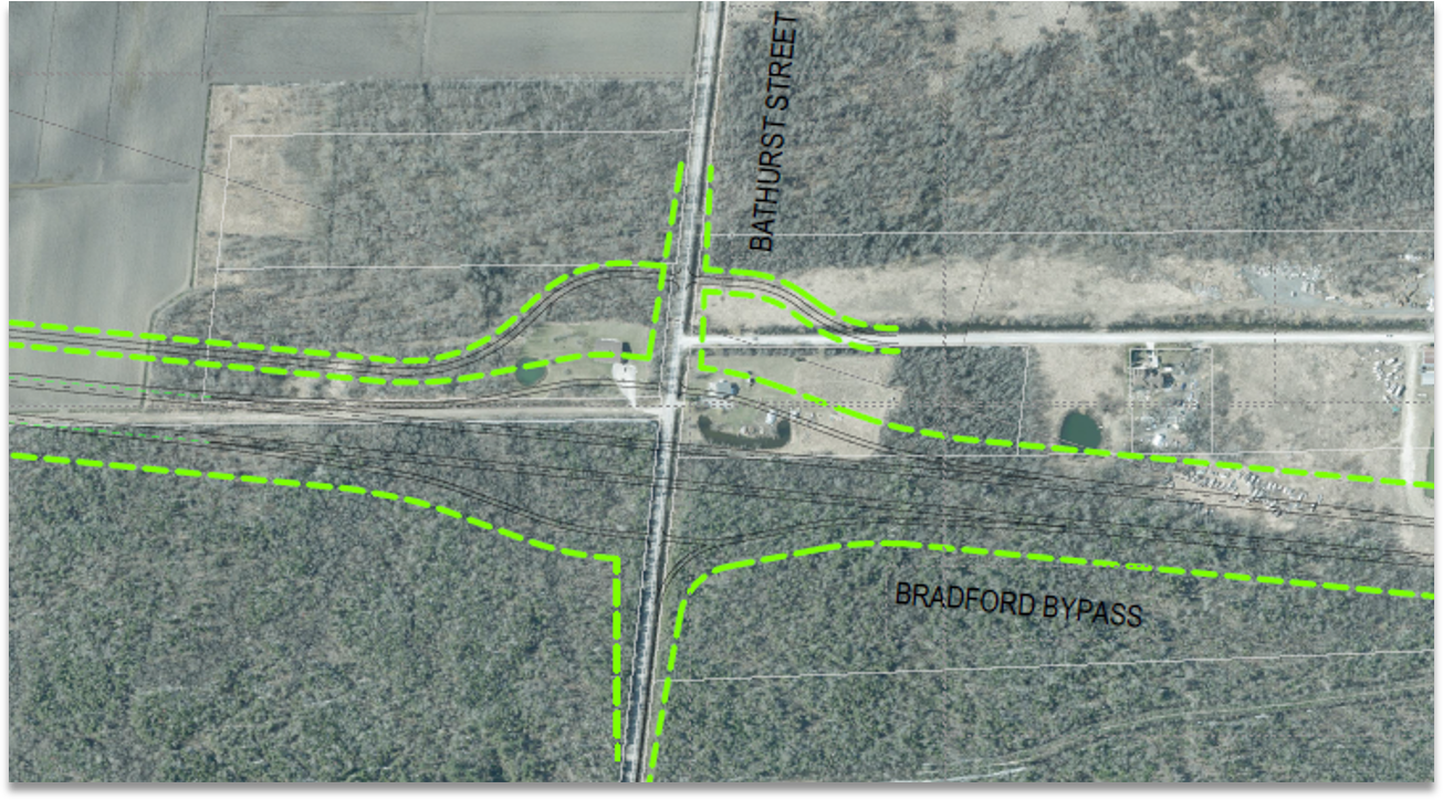
Base Case from 2002 Approved EA Alignment

Bathurst Street Interchange Base Case Map

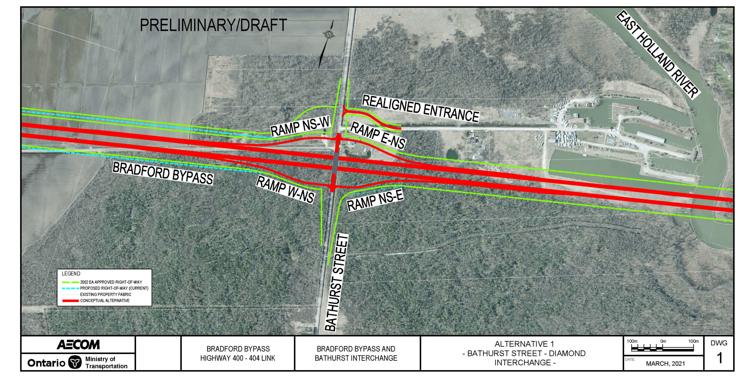
Refinement Alternative 1 - Diamond Interchange

(click to enlarge)

Refinement Alternative 1

  • Consists of two on-ramps and two off-ramps.
  • Traffic signals at the end of two off-ramps (if warranted).
  • Bradford Bypass bridge over Bathurst Street.
  • Property footprint follows the same alignment as the 2002 Approved EA Right-of-Way.
  • Minor property impacts in the northeast and northwest quadrants.
  • Hochreiter Road connection not included as alternate property access being evaluated.

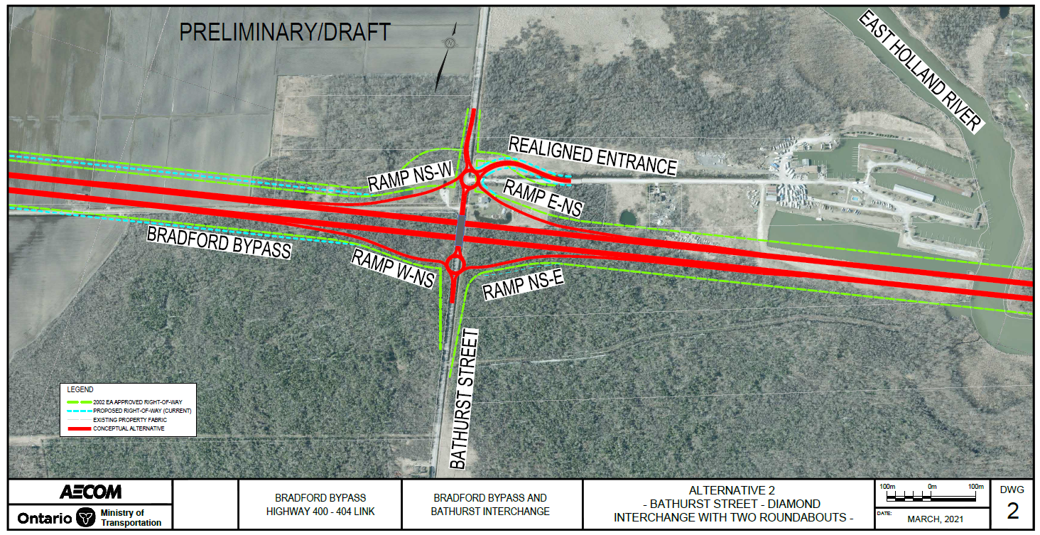
Refinement Alternative 2 - Diamond Interchange with Roundabout at North and South Ramp Terminal

(click to enlarge)

.Refinement Alternative 2 Roundabouts

  • Consists of two on-ramps and two off-ramps.
  • Traffic signals at the end of two off-ramps (if warranted).
  • Bradford Bypass bridge over Bathurst Street.
  • Property footprint is beyond the 2002 Approved EA Right-of-Way.
  • Minor property impacts in the northeast and northwest quadrants.
  • Hochreiter Road connection not included as alternate property access being evaluated.

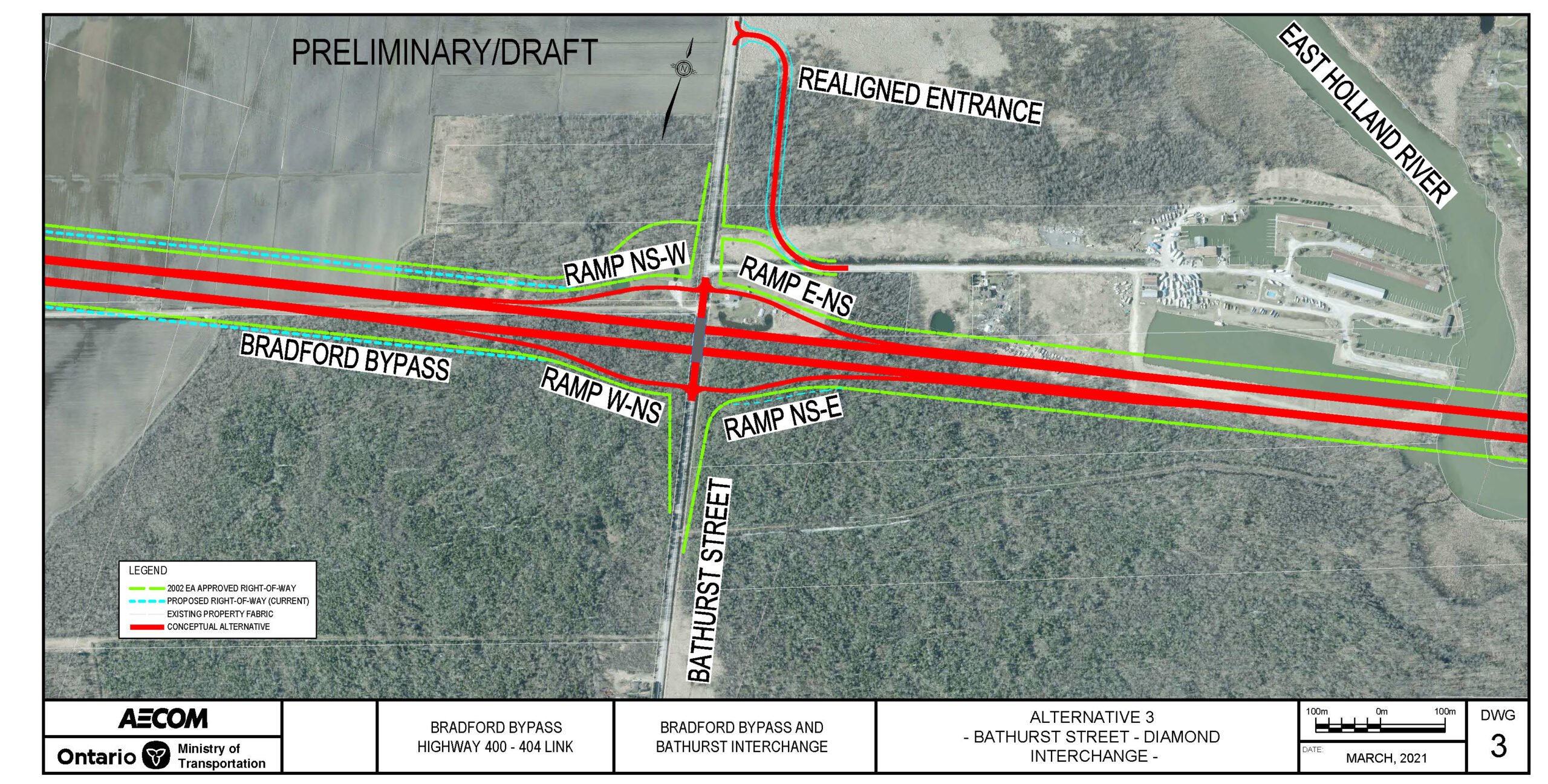
Refinement Alternative 3 - Diamond Interchange

(click to enlarge)

Refinement Alternative 3 Realigned Marina Access 450m North

  • Consists of two on-ramps and two off-ramps.
  • Traffic signals at the end of two off-ramps (if warranted).
  • Bradford Bypass bridge over Bathurst Street.
  • Property footprint is beyond the 2002 Approved EA Right-of-Way.
  • Hochreiter Road connection not included as alternate property access being evaluated.

Key Considerations

Environmental

  • Contamination (area of high potential contamination).
  • Fish and Fish Habitat.
  • Groundwater (Highly Vulnerable Aquifers, Wellhead Protection Area, Significant.
  • Groundwater Recharge Area, domestic water wells).
  • Land Use (Greenlands, Protected Countryside).
  • Surface Water (drainage, multiple warm water watercourses).
  • Terrestrial Ecosystems (Species at Risk, provincially significant wetlands, deer wintering areas, woodlots).

Transportation & Engineering

Engineering

  • Interchange configurations.
  • Traffic operations based on demand and level of service.
  • Complexities in traffic staging, constructability and utility relocation.
  • Structural / grading considerations.

Property Impact

  • Residential property impacts.
  • Impacts to property entrances with possible entrance relocation required.

15. County Road 4 Interchange

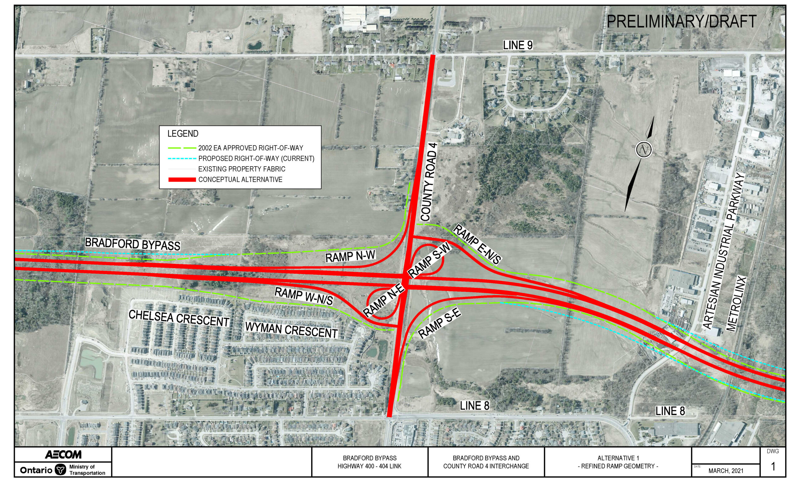
Parclo A4 (2002 Approved EA Alignment)

  • Consists of two direct on-ramps, two loop ramps and two direct off-ramps.
  • Traffic signals at the end of two off-ramps.
  • County Road 4 bridge over the Bradford Bypass.
  • The interchange requires a large property footprint; however, it is contained within the 2002 Approved EA Right-of-Way.
  • Design Considerations for the County Road 4 Widening Municipal Class Environmental Assessment (MCEA) currently being undertaken by Simcoe County. County Road 4 to be widened to 4 lanes, with additional ramp lanes on the bridge.
  • No alternatives are proposed at this location.
(click to enlarge)

Key Considerations

Environmental

  • Archaeological Resources.
  • Built Heritage (two potential Built Heritage Resources).
  • Groundwater (Highly Vulnerable Aquifers).
  • Land Use (Greenlands, Holland Marsh Specialty Area, Settlement Area, Special Policy Area).
  • Terrestrial Ecosystems (Species at Risk, woodlots).

Transportation & Engineering

Engineering

  • Traffic operations based on demand and level of service.
  • Complexities in traffic staging, constructability and utility relocation.

Property Impacts

  • Interchange is within footprint of the 2002 Approved EA.

Adjacent Projects

  • County Road 4 Widening Municipal Class Environmental Assessment (MCEA) currently being undertaken by Simcoe County.

14. Highway 404 Refinement Alternatives

Highway 404 Refinement Alternative 1 - Extend 2-Lanes from Bradford Bypass to Connect with Existing Queensville Sideroad Ramp

  • 750m radius directional ramp at Bradford Bypass eastbound to Highway 404 southbound.
  • Various radii (520m to 600m) directional ramp at Bradford Bypass eastbound to Highway 404 northbound.
  • 440m radius directional ramps at Highway 404 northbound to Bradford Bypass westbound and Highway 404 southbound to Bradford Bypass westbound.
  • Moderate property impacts in the southwest quadrant beyond the 2002 Approved EA Right-of-Way.
  • Minor property impacts in the northwest and southeast quadrants.
  • Northeast quadrant follows the same alignment as the 2002 Approved EA.
Extend 2-Lanes from Bradford Bypass to Connect with Existing Queensville Sideroad Ramp (click to enlarge)

Highway 404 Refinement Alternative 2 - Extend 2-Lanes from Bradford Bypass Beyond Queensville Sideroad and Remove Existing Queensville Sideroad Ramp

  • 750m radius directional ramp at Bradford Bypass eastbound to Highway 404 southbound.
  • Various radii (520m to 600m) directional ramp at Bradford Bypass eastbound to Highway 404 northbound.
  • 440m radius directional ramps at Highway 404 northbound to Bradford Bypass westbound and Highway 404 southbound to Bradford Bypass westbound.
  • Moderate property impacts in the southwest quadrant beyond the 2002 Approved EA Right-of-Way.
  • Minor property impacts in the northwest and southeast quadrants.
  • Northeast quadrant follows the same alignment as the 2002 Approved EA.
Extend 2-Lanes from Bradford Bypass Beyond Queensville Sideroad and Remove Existing Queensville Sideroad Ramp (click to enlarge)

Highway 404 Refinement Alternative 3 - Extend 1-Lane from Bradford Bypass and connect with Existing Ramp at Queensville Sideroad Interchange

  • 750m radius directional ramp at Bradford Bypass eastbound to Highway 404 southbound.
  • Various radius (520m to 600m) directional ramp at Bradford Bypass eastbound to Highway 404 northbound.
  • 440m radius directional ramps at Highway 404 northbound to Bradford Bypass westbound and Highway 404 southbound to Bradford Bypass westbound.
  • Moderate property impacts in the southwest quadrant beyond the 2002 Approved EA Right-of-Way.
  • Minor property impacts in the northwest and southeast quadrants.
  • Northeast quadrant follows the same alignment as the 2002 Approved EA.
Extend 1-Lane from Bradford Bypass and connect with Existing Ramp at Queensville Sideroad Interchange (click to enlarge)

Highway 404 Refinement Alternative 4 - Basketweave at Queensville Sideroad Interchange

  • 750m radius directional ramp at Bradford Bypass eastbound to Highway 404 southbound.
  • Various radius (520m to 600m) directional ramp at Bradford Bypass eastbound to Highway 404 northbound.
  • 440m radius directional ramps at Highway 404 northbound to Bradford Bypass westbound and Highway 404 southbound to Bradford Bypass westbound.
  • Considerable property impact in the southwest quadrant beyond the 2002 Approved EA Right-of-Way.
  • Minor property impacts in the northwest and southwest quadrants.
  • Northeast quadrant follows the same alignment as the 2002 Approved EA.
Basketweave at Queensville Sideroad Interchange (click to enlarge)

Key Considerations

Environmental

  • Built Heritage (two listed Cultural Heritage Landscapes, one potential Cultural Heritage Landscape).
  • Contamination (area of high potential contamination).
  • Fish and Fish Habitat.
  • Groundwater (Wellhead Protection Area, domestic water wells).
  • Land Use (Greenbelt, Whitebelt, Protected Countryside, Greenlands, Holland Marsh Specialty Area, Urban Settlement Area).
  • Surface Water (drainage, multiple warm water watercourses).
  • Terrestrial Ecosystems (Species at Risk, Provincially Significant Wetland, woodlots).

Transportation & Engineering

Engineering

  • Traffic weaving analysis between the freeways and adjacent interchanges (Queensville Sideroad).
  • Traffic operations based on demand and level of service.
  • Complexities in traffic staging and constructability.
  • Structural / grading considerations.

Property Impacts

  • Lands required may extend beyond the 2002 Approved EA Right-of-Way

13. 2002 Approved EA Highway 404 Interchange

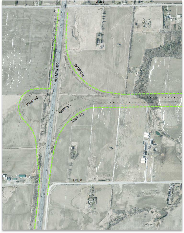
Highway 404 Interchange Base Case from 2002 Approved Environmental Assessment
  • Base case scenario for Freeway-to-Freeway Interchange Design.
  • Designs do not meet current highway design standards.

2002 EA Approved Design Standard Update For Highway Interchanges

  • In advance of the Preliminary Design Study, the Ministry undertook advance works to identify areas where the 2002 Approved EA required updates to meet current design standards. One such location occurred at the proposed interchange with Highway 404.
  • Freeway-to-freeway interchange updates were identified to correct the proposed loop ramps and provide directional freeway-to-freeway ramps to meet current design standards.
  • Preliminary Design refinement alternatives for freeway-to-freeway interchange builds upon the directional freeway ramps only.

Design Considerations

  • General Design Considerations include:
    • Replacement of loop ramps with directional ramps to provide high speed moves for all ramps at Highway 404.
    • 3 level stacked freeway-to-freeway interchange to accommodate four directional ramps.
    • Traffic interactions at adjacent interchanges on Highway 404.

12. Highway 400 Refinement Alternatives

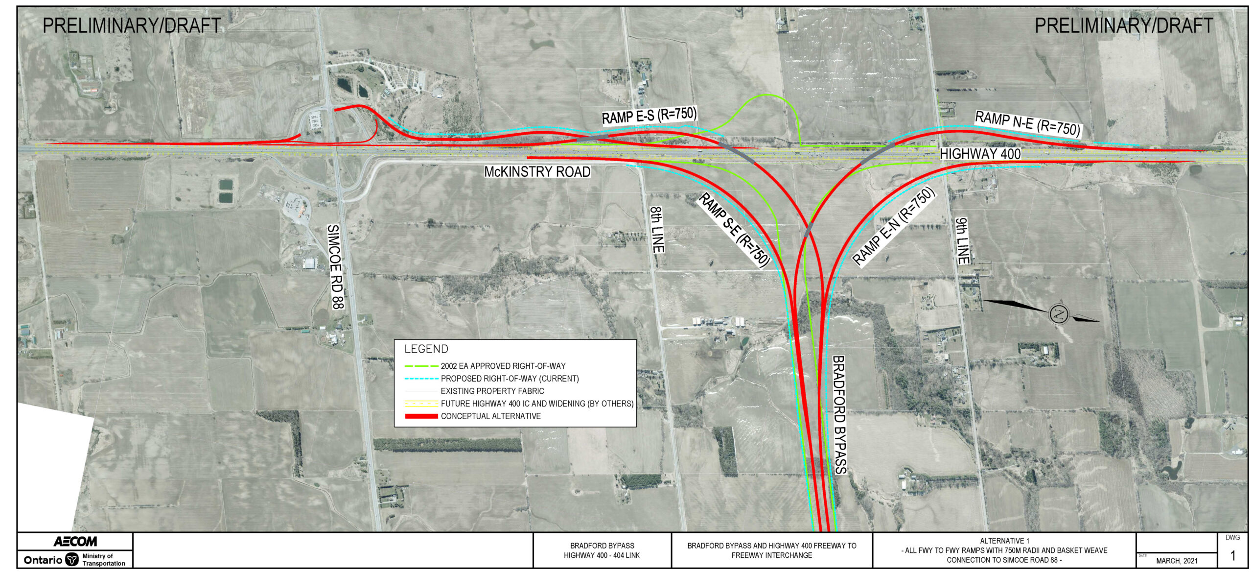
Highway 400 Refinement Alternative 1 - Basketweave on Highway 400 Southbound at Simcoe County Road 88 Exit

  • Basketweave at Highway 400 southbound to Simcoe County Road 88 exit (Level 1) and Bradford Bypass westbound to Highway 400 southbound ramp (Level 2).
  • 750m radius directional ramps.
  • Lands required beyond the 2002 Approved EA Alignment.
    • Larger property impacts in northeast and southeast quadrants.
    • Moderate property impacts in northwest and southwest quadrants.
Basketweave on Highway 400 Southbound at Simcoe County Road 88 Exit (click to enlarge)

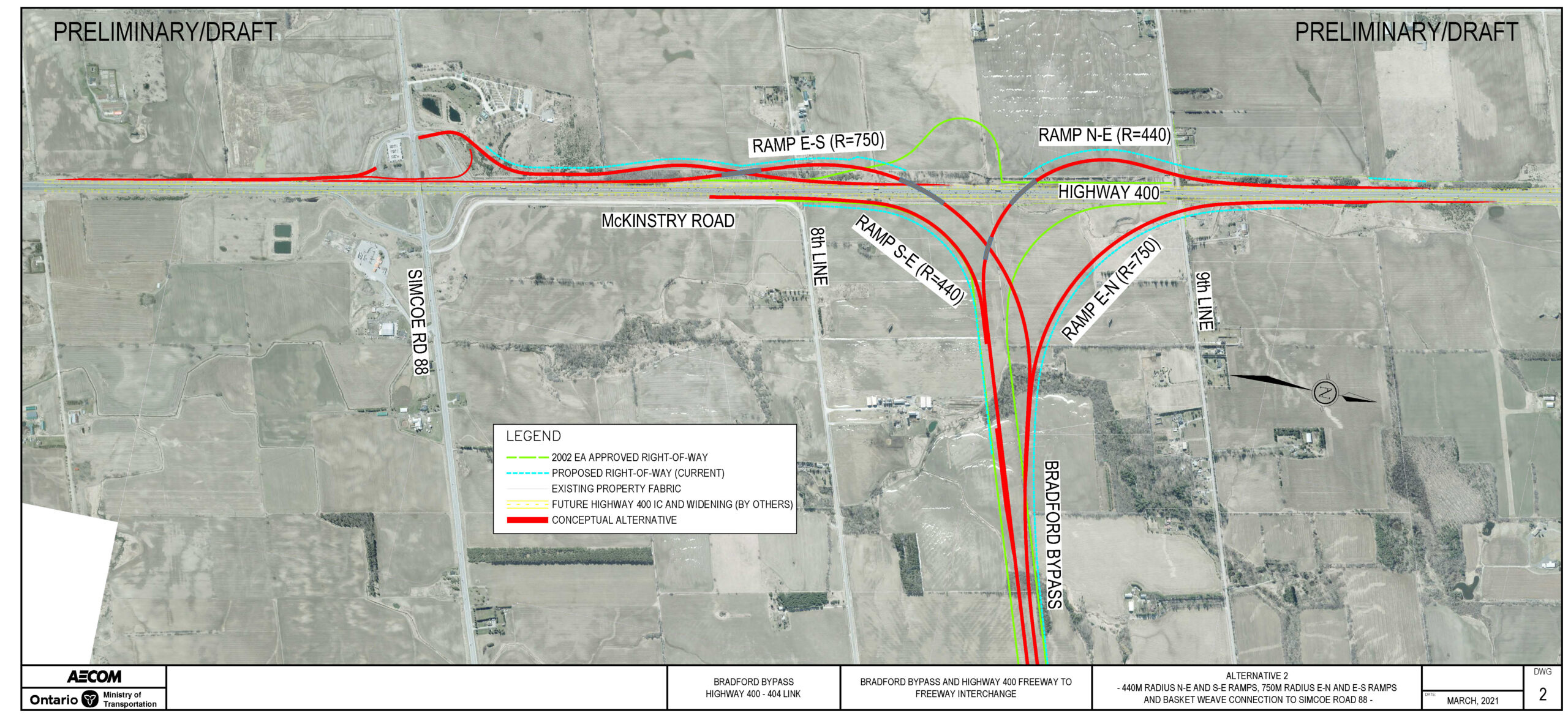
Highway 400 Refinement Alternative 2 - Basketweave on Highway 400 Southbound at Simcoe County Road 88 Exit

  • Basketweave at Highway 400 southbound to Simcoe County Road 88 exit (Level 1) and Bradford Bypass westbound to Highway 400 southbound ramp (Level 2).
  • 750m radius directional ramps at Bradford Bypass westbound to Highway 400 northbound and Bradford Bypass westbound to Highway 400 southbound.
  • 440m radius directional ramps at Highway 400 southbound to Bradford Bypass eastbound and Highway 400 northbound to Bradford Bypass eastbound.
  • Lands required beyond the approved 2002 Approved EA Alignment.
    • Larger property impacts in northeast quadrant.
    • Moderate property impacts in northwest and southwest quadrants.
    • Minor property impacts in the southeast quadrant.
Basketweave on Highway 400 Southbound at Simcoe County Road 88 Exit (click to enlarge)

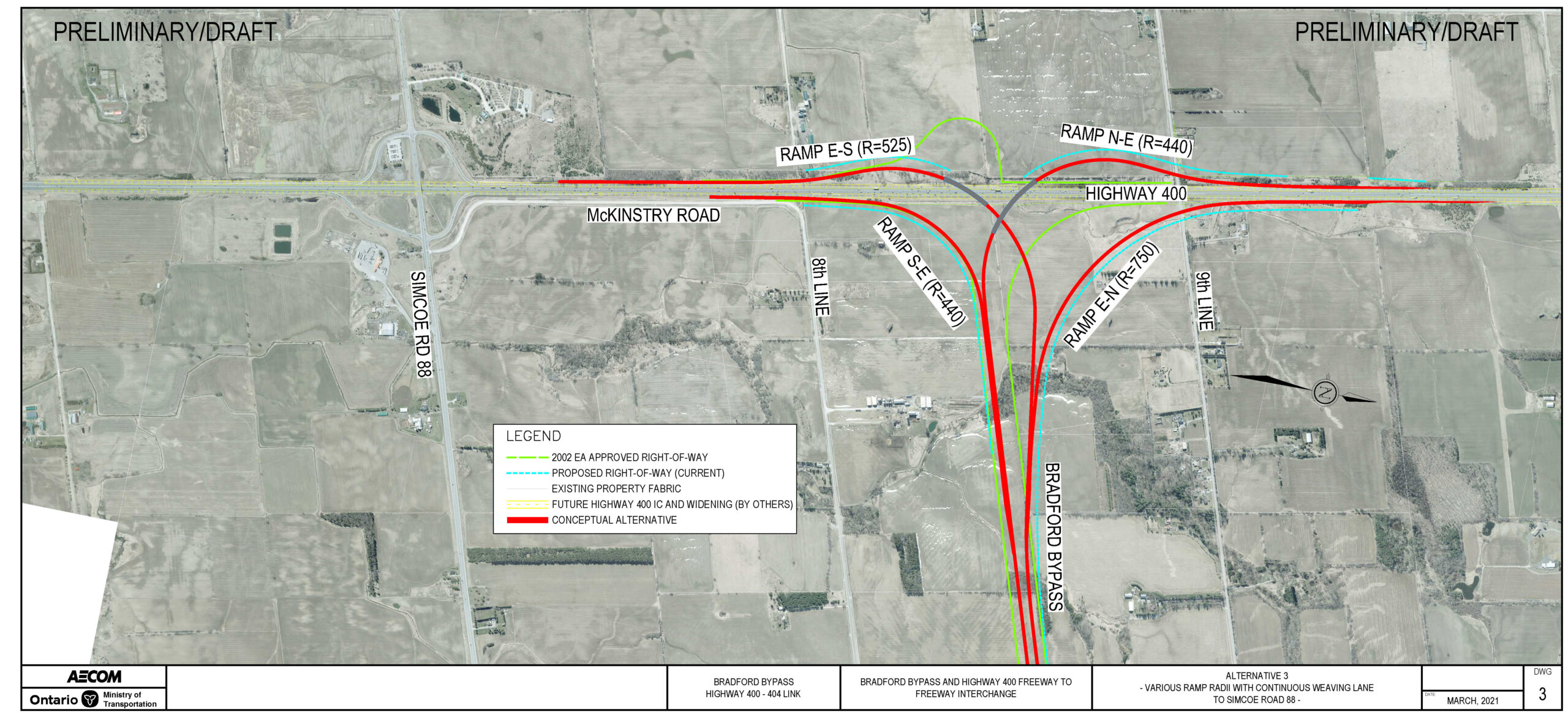
Highway 400 Refinement Alternative 3 - Directional Ramps Without Basketweave

  • 750m radius directional ramp at Bradford Bypass westbound to Highway 400 northbound.
  • 525m radius directional ramp at Bradford Bypass westbound to Highway 400 southbound.
  • 440m radius directional ramps at Highway 400 northbound to Bradford Bypass eastbound and Highway 400 southbound to Bradford Bypass eastbound.
  • Lands required beyond the 2002 Approved EA Alignment.
    • Larger property impacts in northeast quadrant.
    • Moderate property impacts in northwest quadrant.
    • Minor property impacts in the southeast and southwest quadrant.
Directional ramps without basketweave (click to enlarge)

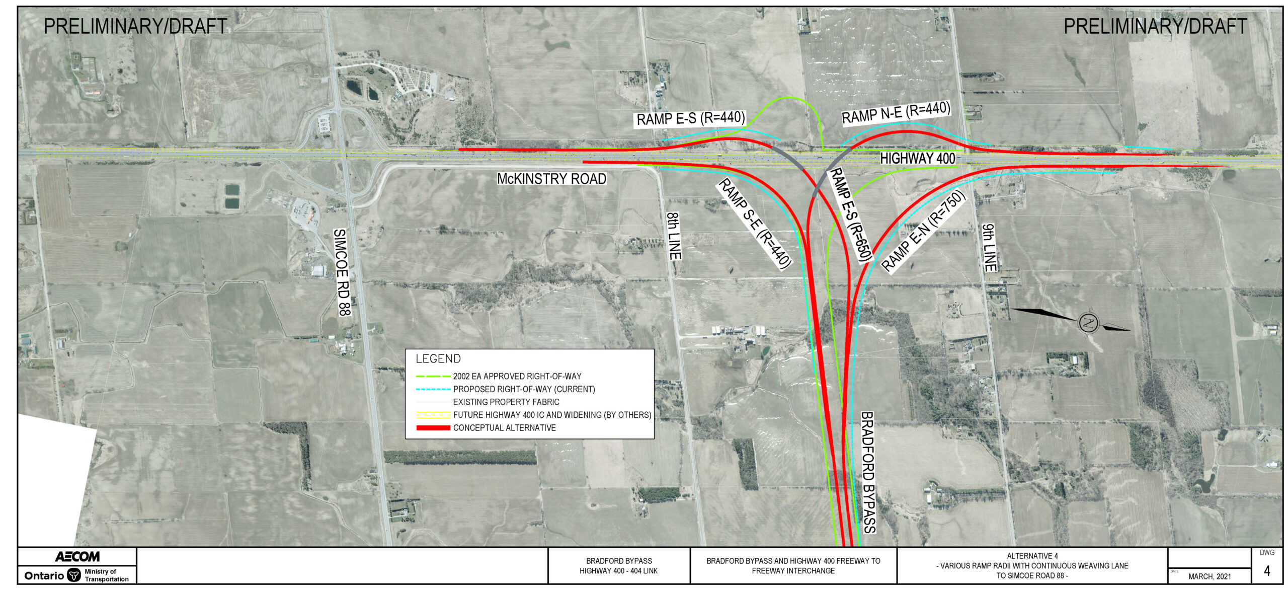
Highway 400 Refinement Alternative 4 - Directional Ramps Without Basketweave

  • 750m radius directional ramp at Bradford Bypass westbound to Highway 400 northbound.
  • Various (440m to 650m) radii directional ramp at Bradford Bypass westbound to Highway 400 soutbound.
  • 440m radius directional ramps at Highway 400 northbound to Bradford Bypass eastbound and Highway 400 southbound to Bradford Bypass eastbound.
  • Lands required beyond the 2002 Approved EA Alignment.
    • Larger property impacts in northeast quadrant.
    • Moderate property impacts in northwest quadrant.
    • Minor additional property impacts in the southeast and southwest quadrant.
Directional ramps without basketweave (click to enlarge)

Key Considerations

Environmental

  • Archaeological Resources
  • Built Heritage (two listed Cultural Heritage Landscapes, one potential Cultural Heritage
  • Landscape, one listed Built Heritage Resource)
  • Sutherland Wesleyan Methodist Cemetery and Rogers Cemetery
  • Contamination (areas of medium and high potential contamination)
  • Fish and Fish Habitat (specialized habitat)
  • Groundwater (Highly Vulnerable Aquifers, domestic water wells)
  • Land Use (Greenlands, Strategic Settlement Employment Area, Agricultural,
  • Surface Water (drainage, multiple coolwater and unknown thermal regime watercourses)
  • Terrestrial Ecosystems (Species at Risk, unevaluated wetlands, woodlots)

Transportation & Engineering

Engineering

  • Traffic weaving analysis between the freeways and the adjacent interchange (Simcoe County Road 88 Interchange)
  • Traffic Operations based on demand and level of service (LOS)
  • Complexities in Traffic staging and constructability
  • Structural / grading considerations

Property Impacts

  • Lands required may extend beyond the 2002 Approved EA ROW

11. 2002 Approved EA Highway 400 interchange

Highway 400 Interchange Base Case from 2002 Approved Environmental Assessment
  • Base case scenario for Freeway-to-Freeway Interchange Design.
  • Designs do not meet current highway design standards.

2002 EA Approved Design Standard Update For Highway Interchanges

  • In advance of the Preliminary Design Study, the Ministry undertook advance works to identify areas where the 2002 Approved EA required updates to meet current design standards. One such location occurred at the proposed interchange with Highway 400.
  • Freeway-to-freeway interchange updates were identified to correct the proposed loop ramps and provide directional freeway-to-freeway ramps to meet current design standards.
  • Preliminary Design refinement alternatives for freeway-to-freeway interchange builds upon the directional freeway ramps only.

Design Considerations

  • General Design Considerations include:
    • Replacement of loop ramps with directional ramps to provide high speed moves for all ramps at Highway 400.
    • 3 level stacked freeway-to-freeway interchange to accommodate four directional ramps.
    • Accommodations for the existing cemetery at 8th Line adjacent to Highway 400.
    • Traffic interactions at adjacent interchanges on Highway 400.

10. Bradford Bypass Mainline Refinement – Hydro Tower Relocation

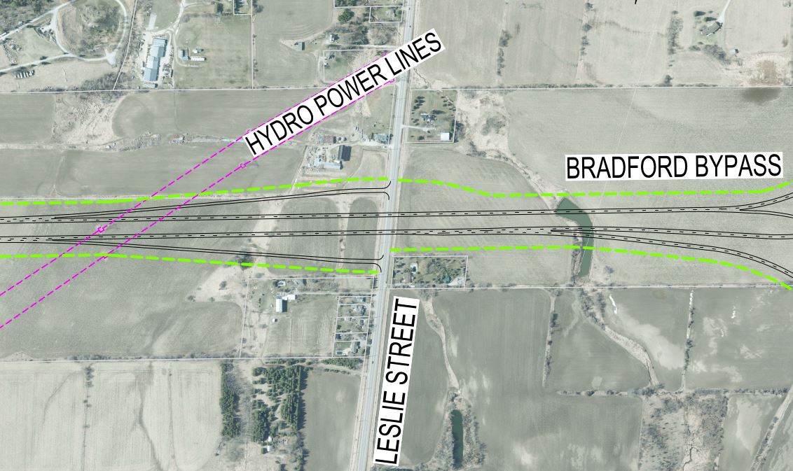
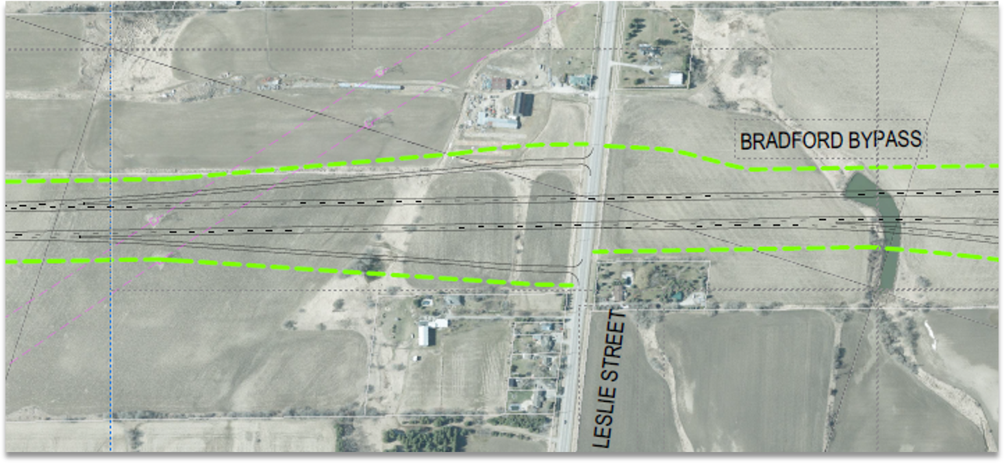
2002 Approved EA Alignment

  • Alignment from the 2002 Approved EA is maintained.
  • Impacts to at least two existing Hydro Towers requires relocation.
Mainline Base Case at Hydro Tower Crossing west of Leslie Street from 2002 Approved Environmental Assessment

Refinement Alternative 1 – Alignment Shift To The North

Realign Bradford Bypass Lanes to the North

  • Gradual realignment of the Bradford Bypass approximately 50 metres to the north.
  • Potentially avoids the need to relocate Hydro Towers.
  • Moderate additional property impacts. Additional property beyond the 2002 Approved EA required in the northeast and northwest quadrants of the Leslie Street interchange.
(click to enlarge)

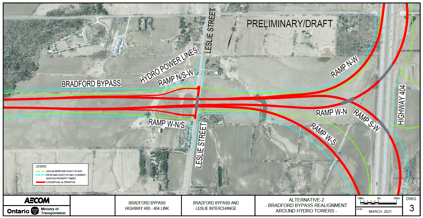
Refinement Alternative 2 – Alignment Flare Around Hydro Tower

Maintain Hydro Tower in the median, and realign Bradford Bypass Lanes to the North and South

  • Gradual flare of the Bradford Bypass westbound lanes to the North and eastbound lanes to the South, requiring approximately 20 metres of additional property on both sides compared to the Base Case.
  • Potentially avoids the need to relocate Hydro Towers.
  • Moderate property impacts. Additional property beyond the 2002 Approved EA required in the northwest and southwest quadrants of the Leslie Street interchange.
(click to enlarge)

Key Considerations

Environmental

  • Built Heritage (Listed Cultural Heritage Landscape north of alignment)
  • Fish and Fish Habitat
  • Land Use (Whitebelt)
  • Surface Water (drainage, warm water watercourses east and west of hydro lines)

Transportation & Engineering

Hydro Utility Corridor Requirements

  • Setback requirements from towers.
  • Access to towers for maintenance.

Highway Design – Geometrics

  • Current design standards to facilitate hydro utility corridor requirements.

Property Impacts

  • Additional property required beyond the 2002 Approved EA.

9. Bradford Bypass Mainline Refinement – Holland River East Branch Crossing

2002 Approved EA Alignment

  • Follows the original alignment in the 2002 Approved EA.
  • Proposes twin structures for eastbound and westbound lanes.
Mainline Base Case at Holland River East Branch Crossing from 2002 Approved Environmental Assessment
Base Case from 2002 Approved EA Alignment

Refinement Alternative 1 – Curved Transition East of River Crossing

  • Bradford Bypass between Bathurst Street to east of Yonge Street is realigned by approximately 150m to the south.
  • Realignment transitions back to existing alignment just east of Yonge Street.
  • Proposes twin structures for eastbound and westbound lanes.
  • This proposed refinement alternative provides less impact to the meandering river.
  • Mitigates property impacts to Albert’s Marina and Silver Lakes Golf Course.
  • Impacts to residential land parcels at Yonge Street.
  • Additional property required beyond the 2002 Approved EA Right-of-Way.
  • Avoids Archaeological Site BAGV 42.
(click to enlarge)

Refinement Alternative 2 – Tangent Transition East of River Crossing

  • Bradford Bypass between Bathurst Street to east of Yonge Street is realigned by approximately 150m to the south.
  • Realignment ties into the existing alignment 1km east of Yonge Street resulting in fewer curves.
  • Proposes twin structures for eastbound and westbound lanes.
  • This proposed refinement alternative provides less impact to the meandering river.
  • Mitigates property impacts to Albert’s Marina and Silver Lakes Golf Course.
  • Impacts to residential land parcels at Yonge Street.
  • Additional Property required beyond the 2002 Approved EA Right-of-Way.
  • Avoids Archaeological Site BAGV 42.
(click to enlarge)

Key Considerations

Environmental

  • Archaeological Resources
  • Contamination (area of high potential contamination)
  • Fish and Fish Habitat (specialized habitat)
  • Groundwater (Highly Vulnerable Aquifers)
  • Land Use (Greenbelt, Holland Marsh Specialty Area)
  • Navigation (clearance requirements)
  • Surface Water and Fluvial Geomorphology (drainage, natural channel patterns)
  • Terrestrial Ecosystems (Provincially Significant Wetlands, Species at Risk)

Transportation & Engineering

Highway Design – Geometrics

  • Bradford Bypass between Bathurst Street to east of Yonge Street is realigned up to 150m south of the original alignment to facilitate structural/ foundations engineering.

Property Impacts

  • Lands required are beyond the Right-of-Way for the 2002 Approved EA Alignment.
  • Mitigates property impacts to Albert's Marina and Silver Lakes Golf Course.
  • Impacts to residential land parcels at Yonge Street.
Skip to content