8. General Design Refinements

Crossing Structures

Preliminary Design Review of Road Crossing Structures as Overpass or Underpasses

Proposed Overpass*

Road Crossing Locations:

  • 9th Line at Highway 400
  • 10th Sideroad
  • Artesian Industrial Parkway
  • Metrolinx Rail Line
  • Holland River
  • Bathurst Street Interchange
  • Holland River East Branch
  • Yonge Street
  • 2nd Concession Road
  • Leslie Street Interchange

Proposed Underpass*

Road Crossing Locations:

  • Professor Day Drive
  • County Road 4 Interchange

*Note: Decisions at these locations are preliminary and subject to change as the design progresses 

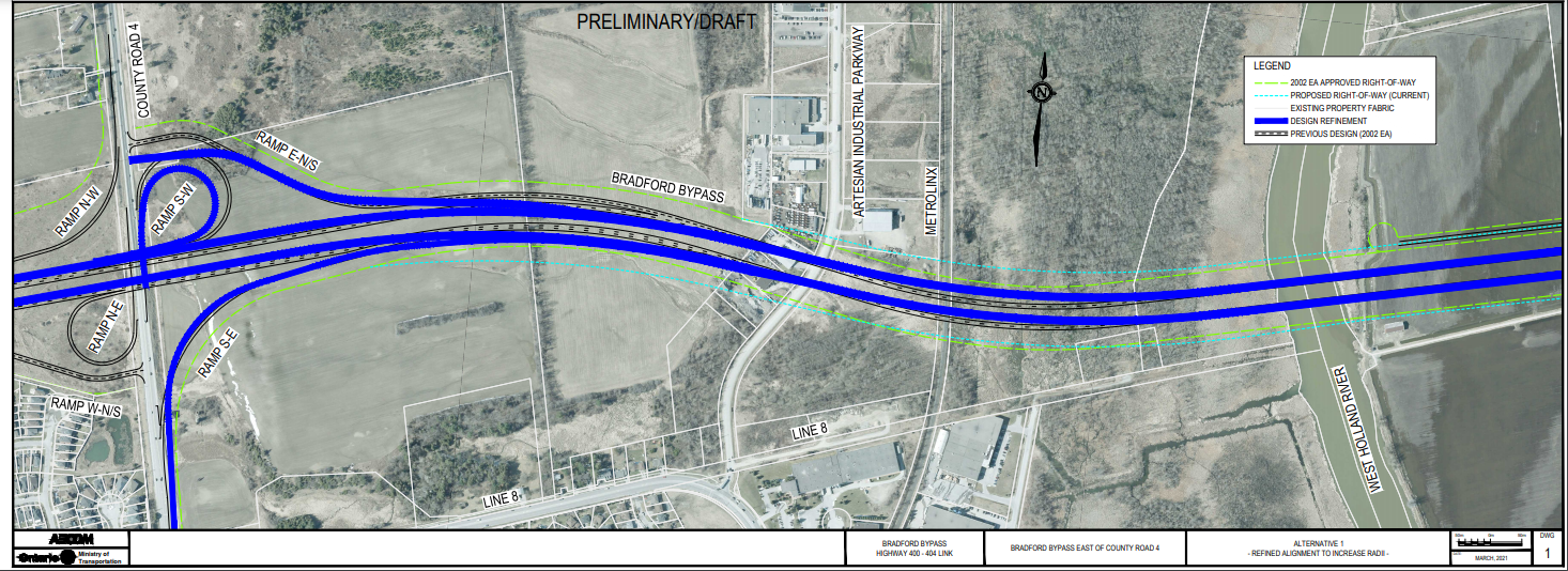
Highway Alignment Refinement Alternative

Professor Day Drive Base Case from 2002 Approved EA

Base Case for Professor Day Drive

Refinement Alternative 1

(click to enlarge)

Highway Alignment Refinement Alternative

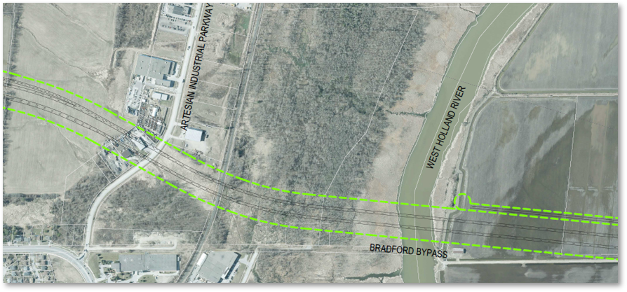
Artesian Industrial Parkway Base Case from 2002 Approved EA and Refinement

Corrects the radii for two horizontal curves in order to meet current Safety Requirements

Industrial Base Case
(click to enlarge)

6. Overall Environmental Considerations Bradford Bypass

Environmental Considerations for the Project

  • Agricultural Lands
  • Air Quality (greenhouse gases, traffic emissions)
  • Archaeological Resources
  • Built Heritage (Built Heritage Resources, Cultural Heritage Landscapes)
  • Community Effects (agricultural, industrial, residential, commercial)
  • Contamination (areas of medium or high potential contamination)
  • Erosion and Sediment Control
  • Fish and Fish Habitat (Species at Risk, specialized habitat)
  • Groundwater (Highly Vulnerable Aquifers, Significant Groundwater Recharge Areas, Wellhead Protection Areas, water wells)
  • Human Health
  • Land Use (Designated Areas, Policy Areas)
  • Landscape and Snowdrift (aesthetics, revegetation, highway safety)
  • Noise (construction noise, traffic noise)
  • Surface Water (drainage, fluvial geomorphology, watercourses/waterbodies)
  • Terrestrial Ecosystem (Species at Risk, Areas of Natural Significance and Importance, wetlands, woodlots, deer wintering areas)

The following outline existing environmental conditions and considerations for the Natural Environment, Socio-Economic Environment, and Cultural Environment. These will be updated and assessed throughout the study.

Natural Environment

Surface Water/Fish and Fish Habitat

  • Watersheds for Nottawasaga Valley & Lake Simcoe.
  • Twenty-eight (28) Watercourses (warmwater/coolwater).
    • Habitat protection for the American Eel will be considered for future field work.
    • Specialized habitat for Northern Pike exists within the Project Limits.
  • Holland River Marsh Provincially Significant Life Science Area of Natural and Scientific Interest (ANSI).

Terrestrial Ecosystems

  • Provincially Significant Wetlands (Holland Marsh, Holland Marsh Wetland Complex, Maskinonge River Wetland Complex).
  • Species at Risk and Species of Conservation Concern (Barn Swallow, Bobolink, Eastern Meadowlark, Louisiana Waterthrush, Bank Swallow, Chimney Swift, Eastern Whip-poor-will, Least Bittern, Little Brown Myotis, Eastern Small-footed Myotis, Northern Myotis, Tri-colored Bat, Jefferson Salamander, Blanding’s Turtle, Butternut, black ash, early-branching panicgrass, Houghton’s flatsedge, bristly buttercup).

Groundwater

  • Higher risk areas within vulnerable areas including: Wellhead Protection Areas, Highly Vulnerable Aquifers, Significant Groundwater Recharge Areas, Intake Protection Zones and along the valleys of Holland River and Holland River East Branch.

Socio-Economic Environment

Land Use

  • The surrounding area of the project is primarily within Greenbelt Plan Area and Prime Agricultural land.
  • There are some businesses and industries operations within the corridor that the Bradford Bypass will impact (i.e., businesses on Artesian Industrial Parkway, etc.).
  • The 2002 Approved EA recommend plan will impact property occupied by parts of Albert’s Marina and Silver Lakes Golf Club on either side of the Holland River East Branch.
  • Anticipated direct impact on several residential properties within the Residential Built Up and Low-Density Residential lands alignment on the west side of County Road 4 in the Town of Bradford West Gwillimbury is also anticipated.

Contamination

  • 29 properties/facilities within the vicinity of the project have a high potential for environmental contamination; 14 properties/facilities with medium potential for environmental contamination.
  • 6 significant spill locations were also identified as having a “high” potential to impact the soil and groundwater quality within the vicinity of the project.

Navigation

  • Navigability and maintaining proper access to the Holland River and Holland River East Branch will be taken into consideration during the preliminary design of the Bradford Bypass and bridge structures. The Project Team is actively engaging with Transport Canada to design the bridge structures to maintain compliance with the Canadian Navigable Waters Act.
  • The Project Team is engaging the public and boaters to understand the vessel types and usage needs of the river with respect to navigation.

Cultural Environment

Archaeological Resources

  • 21 Archaeological sites were found in or within 50m of the study corridor during the Stage 1 Archaeological Assessment (AA) conducted in 2019. These include:
    • 12 19th century Euro-Canadian historic sites and 1 post contact Indigenous site
    • 4 precontact Indigenous sites
    • 2 multi-component sites representing more than one period of occupation
    • 2 sites which lack the information within the database to make an accurate cultural affiliation
  • Undiscovered archaeological sites and resources may still be present with the corridor, which is undergoing additional archaeological investigations with participation by Indigenous Community monitors.

Built Heritage

  • 8 Built Heritage Resources (BHRs) and 13 Cultural Heritage Landscapes (CHLs) were identified within and immediately adjacent to the corridor. Most heritage resources identified are buildings associated with the agricultural economy of the region throughout the 19th and early-20th centuries.

5. Considerations for the Bradford Bypass Project

Traffic

Methodology

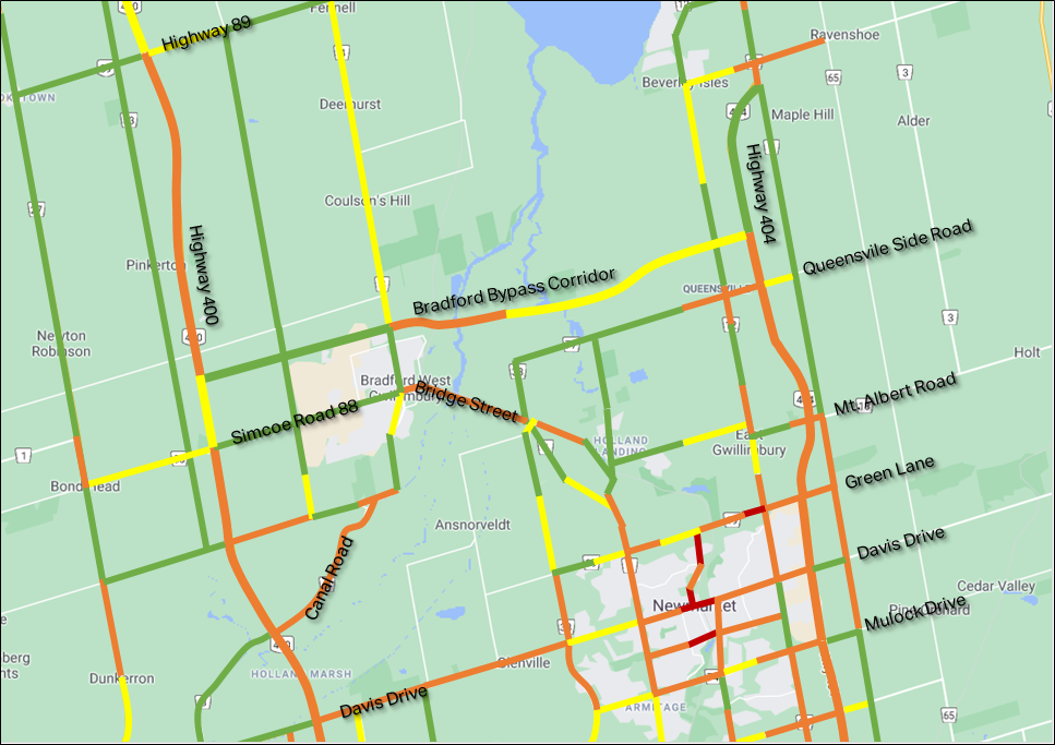
  • Considered 2020, 2041 No Bradford Bypass, and 2041 Bypass scenarios.
  • Compared demand versus capacity on road sections using the Bradford Bypass and no Bradford Bypass scenarios.

Findings

  • Bradford Bypass alleviates capacity issues on key roads.
  • Introduction of Bradford Bypass Corridor decreases capacity use to 76%.

Road Network without Bradford Bypass (2041)

(click to enlarge)

Road Network with Bradford Bypass (2041)

(click to enlarge)

Interchange Selection

  • Interchange locations and route previously identified in the 2002 Approved EA Study through weighting/scoring method.
  • Updated travel demand forecast uses new traffic data to confirm findings of the 2002 Approved EA.
  • Interchange alternatives being developed for each previously identified location.
(click to enlarge)

Adjacent Projects

Highway 400/ County Road 88

  • Detail Design for the replacement of the County Road 88 underpass and reconfiguration of the Highway 400/ County Road 88 Interchange.
  • Design considerations for ramp configurations and highway connections between the Highway 400 / Bradford Bypass Interchange and the Highway 400/ County Road interchange.

Highway 400/ 9th Line

  • Detail Design for the replacement of the Highway 400/9th Line overpass structure.
  • Design and Environmental Assessment considerations for the proposed replacement of the Highway 400 / 9th Line structure.

County 4 Widening

  • County of Simcoe completed a Municipal Class EA for the widening of County Road 4 from 8th Line to just north of the Intersection of County Road 89 (May 2012).
  • Design to account for the overlap between the proposed widening of County Road 4 and the proposed Bradford Bypass / County Road 4 interchange.

Applicable Environmental Legislations and Approvals to be Considered

Federal

  • Canadian Navigable Waters Act
  • Fisheries Act
  • Migratory Bird Convention Act
  • Species at Risk Act
  • Impact Assessment Act*

*At the time of this PIC, a decision is pending as to whether this study will be required to undergo an EA under the Federal Impact Assessment Act.

Provincial

  • 2002 Approved EA and MECP Conditions of Approval
  • Clean Water Act
  • Endangered Species Act
  • Environmental Activity and Sector Registry (construction dewatering)
  • Environmental Assessment Act (Class EA for Provincial Transportation Facilities)
  • Environmental Protection Act
  • Greenbelt Plan
  • Lake Simcoe Protection Act
  • Lakes and Rivers Improvement Act
  • Ontario Heritage Act
  • Permit to Take Water
  • Planning Act
  • Provincial Policy Statement
  • Safe Drinking Water Act
  • Water Resources Act

Municipal

  • Conservation Authority Regulations
  • Noise By-Laws
  • Official Plans
  • Road Occupancy Permit/Road Closure Permit
  • Site Plan Review

The Ministry will continue to review and consider applicability of federal, provincial and municipal legislation for the project.

4. Overall Considerations for Bradford Bypass Project

Bradford Bypass History and Initial Design Updates

2002 Approved EA

  • Route Planning Study completed in 1997.
  • Environmental Assessment Approval in 2002.
  • Highway right-of-way designation for the Bradford Bypass between Highway 400 and Highway 404 received in May 2004.

Update in Advance of Preliminary Design Study

  • In advance of the Preliminary Design, the Ministry identified two modifications to the mainline alignment to reduce existing development impacts, and to update the alignment to meet designs standards as follows:
  • Alignment Adjustment: Between 10th Sideroad and Regional Road 4, the approved alignment was shifted towards the north by 10m to mitigate impacts to an existing development.
  • Alignment Refinement: To meet current standards in the vicinity of Artesian Industrial Parkway.

Engineering Considerations Bradford Bypass (Overall)

Transportation

Highway

  • Interchange configurations and Highway Geometrics
  • Grading considerations
  • Traffic Volume (demand)
  • Traffic Operations (Level of Service)
  • Traffic Operating Speed (design speeds)
  • Safety
  • Traffic Staging
  • Constructability

Structural

  • Bridges, Culverts & Structural Design
  • Retaining Walls & Noise Barrier Walls
  • Foundations & Geotechnical
  • Navigability
  • Constructability
  • Traffic Staging

Other

  • Utilities
  • Drainage and Stormwater Management
  • Financial (cost)
  • Property impacts
  • Active Transportation
  • Traffic Management Systems
  • Illumination / Traffic signals
  • Pavement Engineering

Traffic – Needs and Justification 2002 Approved EA

Road Discontinuities

  • Inefficient travel as a result of the presence of physical and operational discontinuities.

Future Demand Growth Implications

  • Current road / rail network is inadequate in terms of capacity and location to accommodate future demand.

Lack of Long-Term Plan

  • Lack of a defined, approved long-term highway network plan in northern York Region and southern Simcoe County places constraints on provincial and municipal planning process.

Relieve Congestion

  • Capacity issues identified for east-west travel through northern York Region and southern Simcoe County.

3. Refinements and Alternatives Evaluation Process

Transportation Problems and Opportunities Identified in the 2002 Approved EA Study

The 2002 Approved EA Alignment planning study addressed several transportation problems which were identified in the northern section of York Region and southeastern Simcoe County. The identified problems were related to the Ministry’s mandate to provide for the safe, efficient movement of people and goods between regions and between urban areas.

A travel demand analysis carried out for the study indicated that demand would exceed available capacity, even after accounting for planned road improvements to other east-west highway corridors in the area.

Transportation Problems and Opportunities addressed by the proposed Bradford Bypass include:

  • Problems with Traffic Operations
  • Road Discontinuities
  • Future Demand Growth Implications
  • Lack of Long-Term Plan
  • Relieve Congestion
  • Protect Property

Refinements and Alternatives to the Undertaking: Evaluation Criteria & Approach

Alternative

Do Nothing

Preliminary Assessment and Summary

  • No change to the 2002 Approved EA Approved mainline alignment, proposed road crossings, interchange configurations and freeway-to-freeway connections.
  • Does not meet all of the current highway design standards and objectives.
  • Does not consider new/revised environmental policies/legislation implemented since 2002 Approved EA; potential impacts and mitigation measures may not be accurately captured.

Alternatives

Mainline alignment adjustment

Grade separated crossings

Interchange configurations

Preliminary Assessment and Summary

  • Considers: current design standards, adjustments to highway and road profiles at road crossings, traffic volume, demand, accessibility and safety, constructability, utility conflicts & property impacts, natural environment, social, economic & cultural sensitivities.

Alternative

Freeway-to-Freeway interchanges

Preliminary Assessment and Summary

  • Considers: current highway design standards to provide ramps which are more consistent with current freeway-to-freeway design practices. Traffic volume, demand, accessibility and safety, constructability, utility conflicts & property impacts environmental, social, economic & cultural sensitivities.

Evaluation Criteria and Process

Refinements and Alternatives have been developed and will be evaluated for:

  • Bradford Bypass Mainline
  • Freeway-to-Freeway Interchanges
  • Arterial / Crossing Road Interchanges
  • Design Refinements

A Reasoned Argument (trade-off) method of evaluation will be used to identify the advantages to select the preferred refinements and alternatives.

The criteria outlined below will be used to evaluate the refinements and alternatives.

Evaluation Factor:

Transportation & Engineering

Criteria:

  • Traffic Operations and Safety
  • Highway Geometrics and Design Standards
  • Structural Engineering
  • Foundation and Geotechnical Conditions
  • Active Transportation
  • Utilities and Stormwater Management
  • Constructability and Staging
  • Navigability
  • Cost

Evaluation Factor:

Natural Environment

Criteria:

  • Fish and Fish Habitat
  • Terrestrial Ecosystems
  • Wildlife Crossings
  • Species at Risk
  • Environmentally Significant Features
  • Groundwater
  • Surface Water (Drainage & Hydrology)
  • Drinking Water
  • Fluvial Geomorphology
  • Greenways and Open Space Linkages
  • Climate Change

Evaluation Factor:

Socio-Economic Environment

Criteria:

  • Aesthetics and Landscaping
  • Noise, Vibration and Air Quality
  • Contamination and Property Waste
  • Residential Property
  • Agricultural Lands
  • Land Use (Policy Areas, Designated Areas)
  • Approved Plans and Policies
  • Snowdrift
  • Human Health

Evaluation Factor:

Cultural Environment

Criteria:

  • Archaeological Resources
  • Built Heritage and Cultural Landscapes
  • Indigenous Communities and Treaty Rights

Generation of Design Refinements and Alternatives

The displays and material for the project have been divided into the following three sections for the purpose of evaluating the refinements and alternatives:

  • Preliminary Design Refinements of Bradford Bypass
    • Mainline Refinements
    • Holland River East Branch Crossing
    • Hydro Tower crossing
  • Freeway-to-Freeway Interchange Refinement Alternatives
    • Highway 400
    • Highway 404
  • Arterial/Crossing Road Interchange Refinement Alternatives
    • County Road 4
    • Bathurst Street
    • Leslie Street

2. Study Process

Study Process

Environmental Assessment Principles

  • This study will follow the study process for a Group ‘A’ project in accordance with the MTO Class Environmental Assessment for Provincial Transportation Facilities.

Consultation Principles

  • Carryout consultation to present the Preliminary Design and Environmental Assessment to engage the public, regulatory agencies, and Indigenous communities and solicit feedback.
  • Receive and respond to questions and feedback received from stakeholders.
  • Hold meetings with Indigenous communities, municipalities, regulatory agencies, impacted property owners and community groups.
  • Hold future PIC (anticipated for Fall 2022).

Transportation Principles

  • Develop Preliminary Design Refinements and Alternatives.
  • Evaluate and Select Preferred Refinements/Alternatives.
  • Develop the Preliminary Design.

Documentation Principles

  • Document the Preliminary Design Study in a Transportation Environmental Study Report (TESR)
    Public and agency review of the TESR for a period of 30-days at the completion of the study.

Study Process Timeline

Route Planning Study 2002 Approved Environmental Assessment

Preliminary Design Notice of Study Commencement

Environmental Protection in Preliminary Design

  • Preliminary Design Refinements and Alternatives Generated and Identify Evaluation Criteria
    • PIC #1 (we are here)

Environmental Protection in Preliminary Design

  • Evaluate and Select the Preliminary Design Refinements/Alternatives

Environmental Protection in Preliminary Design

  • Develop the Preferred Refinements/Alternatives
    • PIC #2

Environmental Protection in Preliminary Design

  • Notice of Study Completion or Filing of the Transportation Environmental Study Report

Next Design Phase (To Be Determined)

Preliminary Design Study Timeline

  • September 2020: Notice of Study Commencement and Permission to Enter and Study Initiation.
  • September 2020 to End of 2022: Field Investigations and Data Collection.
  • September 2020 to April 2021: Generation of Refinements and Alternatives.
  • April 22, 2021 to May 6, 2021 (Webinar May 18, 2021): Public Information Centre #1 (we are here).
  • April 2021 to Fall 2022: Evaluation and Selection of Preferred Refinements/Alternatives.
  • Fall 2022: Public Information Centre #2.
  • End of 2022/Early 2023: Filing of the Transportation Environmental Study Report (TESR).
  • Early 2023: Preliminary Design Anticipated Completion.

1. Project Overview

The Project

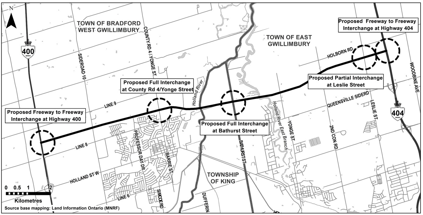
The proposed Highway 400 – Highway 404 Link (Bradford Bypass) is a new 16.2 km rural controlled access freeway between Highway 400 and Highway 404.

The 2002 EA approved alignment will extend from Highway 400 between Lines 8 and 9 in Bradford West Gwillimbury, will cross a small portion of King Township and will connect to Highway 404 between Queensville Sideroad and Holborn Road in East Gwillimbury.

There are proposed full and partial interchanges, as well as grade separated crossings at intersecting municipal roads and watercourses, including the Holland River and Holland River East Branch.

Project Location

The Project is located within Simcoe County (Town of Bradford West Gwillimbury) and the Regional Municipality of York (Township of King and Town of East Gwillimbury).

(click to enlarge)

Bradford Bypass Roll Plan (1 of 2)

2002 Approved EA Alignment – Preliminary Design Base Case

(click to enlarge)

Bradford Bypass Roll Plan (2 of 2)

2002 Approved EA Alignment – Preliminary Design Base Case

(click to enlarge)

How Did We Get Here?

1992-1997 – Route Planning and Environmental Assessment Study

Between 1992 and 1997, the Ministry undertook a Route Planning and EA Study per the Environmental Assessment Act, RSO 1990. In December 1997, an EA Report was submitted documenting the EA process for the route selection, right-of-way (ROW) designation and future commitments for the Highway 400-Highway 404 Link. A Notice of Approval to proceed with the undertaking was issued by the Minister of Environment and Energy on August 28, 2002. Carried forward as the 2002 Approved EA Alignment and received legal designation as a Controlled Access Highway in May 2004.

Significant population growth is projected for both Simcoe County and the Regional Municipality of York. The Bradford Bypass has been proposed as a response to this dramatic growth in population and travel demand in the area, including the forecasted increase in congestion on key east-west roadways linking Highway 400 to Highway 404. The proposed location for the Bradford Bypass was also identified in Places to Grow: Growth Plan for the Greater Golden Horseshoe (2019).

2019-Present – Technical Updates and Preliminary Design and Environmental Assessment Study

In August 2019, the MTO approved the re-initiation of design activities for the Bradford Bypass.

2019-2020 – Complete Engineering Design and Environmental technical updates (desktop secondary source review) to the project in recognition of the changes to design standards and environmental legislation relative to those applicable during the Route Planning and EA Study.

2020-present – Undertake the Preliminary Design and Environmental Assessment Study following the approved planning process for a Group ‘A’ project under the MTO Class EA for Provincial Transportation Facilities.

Key Objectives of the Study

The main objectives of the preliminary design study are to review the recommended plans of the 2002 approved EA and undertake refinements and develop refinements and alternatives for the mainline alignment, interchanges and crossings, including:

  • Develop preliminary design refinements for Bradford Bypass mainline alignment, grade separated crossings and interchanges.
  • Develop refinements and alternatives for freeway-to-freeway interchanges that include design concepts to mitigate weaving distance concerns with adjacent interchanges.
  • Evaluate the refinements and alternatives to recommend preferred refinements/alternatives for the above elements.
  • Develop a preferred staging and construction sequencing strategy for the corridor
  • Develop preliminary level design for all highway engineering components.
  • Environmental Assessment Process and Consultation for the project.
Skip to content